S.P.A.Training Division
Flt No. TP8908
Aircraft: Ford Trimotor
Location: Wichita, KS
Weather: The weather to 2000-2500 scattered at 3/8 and 5000-7000 broken at 5/8 clouds. Set the wind to 350 at 8 kts. Fly the leg at 4000 feet MSL
VFR Flight Navigation Lesson
From KICT to 1K5
This flight works well in FS2004 because RR tracks and power lines are included in the scenery and the roads and rivers tend to twist and turn in the proper directions. It does not work well in FS2002 because of the lack of the aforementioned items…but you may certainly give it a try if you wish. It is a 94 mile flight…if you are off by 3 degrees then you will miss the airport by 4.5 miles. Legal VFR is 1000 feet overcast and 3 miles visibility.
This flight is worth double logged time.
This is a lesson in how to fly a VFR flight. This flight is based on Leg number 4 of the TAT (Transcontinental Air Transport) route that was the USA's first passenger carrying operation from coast to coast. It started in 1929 and they flew Ford Tri-motors by day and transferred the passengers to train to travel by night. All nine Legs of the West bound trip are listed within FS2004 to accompany their fine rendition of the Ford Tri-motor.The flying part of the route starts at KCMH (Columbus, OH).
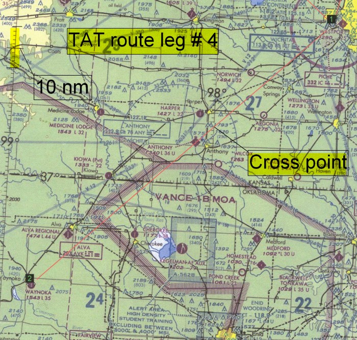
NOTE: The North/South lines at "Cross point" and where noted"10 nm" are lines of Latitude. Each "minute" of Latitude is equal to roughly one nautical mile. Thus the reference to 10nm in the upper left corner of the above chart for distance reference.
Your Magnetic Variation in this area is 7 degrees East. You subtract East variation and you would add West variation to your True Course (East is least and West is best) to get your Magnetic Course.
Find:
- True course from KICT to 1K5.
- Convert your True Course to Magnetic Course.
- Mark prominent check points along your route with mileage ticks to check your progress.
- Calculate your route distance.
- Calculate the effect of wind (350/08) on your flight.
- Calculate time for each segment and total route.
- Calculate how much fuel is needed for your flight (add 45 minutes more than needed).
Calculate:
- TRUE COURSE > Lay a protractor over the "Cross point" > (where your route line and the Latitude line cross.) Line up the ref point with the line of Latitude > this will be True North. Count the degrees from your ref. datum around to your course line. ( It should come out as: 228 degrees True.)
- VARIATION > Since your charted variation is 7 degrees East > then you subtract 7 from 228 = 221 degrees. (No wind magnetic course)
- MARK CHECK POINTS > Look at your copy of the above chart. Mark a short line across your course line at the following locations:
- Where the RR track crosses your course line just NW of the city of Conway. (20nm SW)
- Over the airport at Anthony.
- Where you cross the RR track between the two little airports of Kiowa & Cherokee.
- Abeam the airport of Alva.
- ROUTE DISTANCE> Make a mileage ruler using the "10 nm" gauge on the chart and measure the distance between each check point and also calculate the total distance for the trip.
- EFFECT OF WIND > Down load this little "Time/Distance calculator" (the second one down the page) and enter the required data to figure out your wind drift correction angle and new Ground Speed. Or use your own E6B if you have one.
- CALCULATE TIMES > Using the new Ground Speed you figured in # 5 above figure your times between check points, and estimated time for entire leg. Make sure they match each other as a matter of cross check. You may use the same calculator you downloaded from above, or your E6B, or use this formula: " NM divided by Speed (kts) X 60 = minutes".
- FUEL > You now know the time needed to fly between KICT and 1K5. You should know the fuel burn in pounds per/hour of your aircraft. Multiply your time enroute by your fuel burn per/hour and add 45 minutes to get your total required fuel on board. You may add as additional 10 minutes for climb fuel if you wish.
MAKE A FLIGHT PLANNING WORKSHEET FOR YOUR TRIP WITH:
Departure time:_________
Time & mileage to each fix:_______
Total time & mileage from KICT to 1K5:________
Keep track of the times you pass over each check point so you know how you are doing and can refigure your groundspeed if needed.